Sun July 25
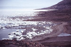
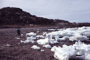
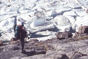
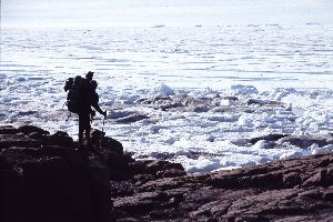
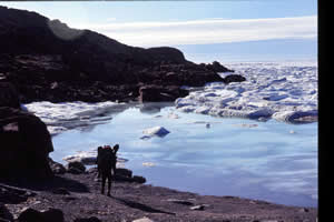
Chatted until late, neither of us sleepy. Hot in the tent about 3am with direct sun hit – unzipped and enjoyed cooling breeze. Mid morning yawns as the sun creeps higher and brighter in the sky. Weather looks good, high clouds but lots of blue around. After exploring around camp, I climb up the small knoll for views across Jones Sound and to scout what’s ahead: as far as the eye can see, broken ice cakes line the shore, huge blocks pushed up by tide and wind.
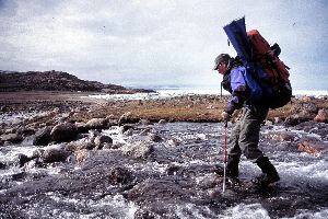
The first little creek we have to cross is not so little. Water levels everywhere seems to be higher than expected for mid summer – we speculate about the fate of glaciers given global warming…finally, we locate a good rock hopping spot further upstream where the river braids and shallows appear. I was hoping the 2nd stream could be crossed where it dumped into the ocean but we ended up backtracking inland again.
These mid lowlands end at the base of cliffs and ocean junction. Instead of walking along sandy beach or level grassy tundra, we are forced up, scrambling around a rocky headland. Cape Skogn juts out about halfway between Truelove Lowlands and the Cape Sparbo-Cape Hardy lowlands. The granite bedrock provides firm footing as we move along the tipped planes of red coloured bedrock. Ocean ice is heavily fractured, brilliant blue waters seep between the ice pans rounded edges. Every so often the sound of water sloshing reaches my ears, the tide jostling the two foot thick ice against the shore.
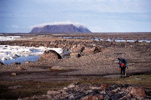
Just before the tip of the Cape we come across a small level area with faint tent rings. The stones are very small, the ring an uneven oval approximately 10 to 12’ in diameter. What an inhospitable site! But perhaps to a kayaker or self sufficient marine hunter, it was a convenient place to drag a seal or walrus to shore for butchering. No bones remain however. We break and snack before moving on. 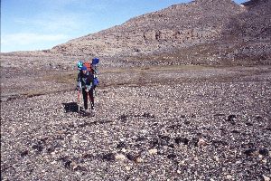
The going is quite different on the east side of the cape: it’s a pure boulder scramble up and down and around huge lumps of stone. There is no obvious path, we search high and close to the water line for any hint of a trail. Eventually, we give up and slog along the path of least resistance. Its frustrating business, several times we have to back track as going forward ends in a sheer drop. The boulders are a mix of grey granite tumbled down from above on top of slabs of red granite polished by wind/ice and snow.
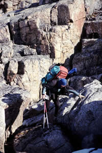
Travel speed is about 1 km per hour. The sun is hot on our backs and I’m thankful the weather is dry, unlike yesterday over this arduous route. Just when we think the worst is over, there is yet another shoulder to get across. We’re getting discouraged and tired. How much longer I wonder? The map suggests a distance of about 3 km but it feels like we’ve gone two or three times that distance.
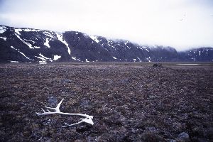
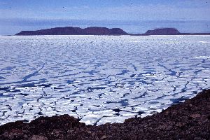
Only the sight of Cape Sparbo and Cape Hardy looming across the water, some 10 km away, keep me going. Their black cloud shrouded peaks look like some medieval fairy castle – can Gollun be far away? We don’t see any seals on the ice but do see three large turds which have to be polar bear. But even the turds are dried up and old, fossilized like rock themselves on this point. Interestingly, we come across four caribou antlers, well weathered and rodent knacked, the first we have found after 10 days on Devon (I read later that caribou were largely shot out from this area in the early 1950’s with the arrival of hunters and a permanent settlement at Grise Fiord).
The up and down wears on the back, the feet and the patience…what a grueling day! It is with huge relief when we round the last corner and verify that the cliff swings inland and level terrain is only metres away. The first thing I see is a huge boulder that anchors one end of an old tent ring – seems others have taken advantage of this last/first bit of ground.
 Our ordeal is not yet over. Mistakenly, we chose the path of least resistance and follow the shore line (a natural over reaction given our last three hours!). Within 1 km, a river to deep to comfortably cross, blocks our passage. There is no choice but to turn back and weave our way between the multitude of small ponds. With a big sigh, we turn to each other and say: ‘next year, it’s the Cook Islands with a fancy drink by the swimming pool’ grrrr!!! Its too wet to camp along the shore, beside the weather is changing and we don’t want to be caught out in the sand in a high wind situation.
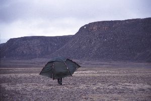
The land gradually rises, in gentle terraced raised beaches similar to the Truelove Lowlands area. A large river streams over the uplands, we follow its banks looking for a place to cross. Eventually, we settle on a small level area with a view of the flats below and set up the tent. While strolling to a small pond for water, I notice an even better tent site 400m away. Nestled between two gentle rises, I like that it is more wind sheltered and can’t be directly seen from the beach. After so many years of waterfront camping in Northern Labrador, the best defense from polar bears is don’t arouse their curiosity - out of sight is a good start. Alfred doesn’t even flinch when I suggest having a look at this alternative site. Gamely and with humour, he picks up the tent and walks it uphill to the new location. How lucky I am to have such a wonderful wilderness companion!
By 10pm we are fed and on the move again, feeling free with no burden on our backs and easy tundra to move across. We walk up, river right, into the valley where it falls over the glacier, the tundra grasses replaced by a rock bowl of gravel and stone, sorted according to size. It’s not a place that further entices me to walk on…Alfred probes deeper. I turn and exit, preferring the relative lushness of old beach terraces the tundra offers, again finding a large whale skull buried, that serves as a poppy garden.
Finally it’s about 1am, +3C, the sky is seriously clouding over. Time to rest the feet and get horizontal. So far, no way across the river, I ponder our move for tomorrow…